
Spiti Valley Photography Tour Pictures and Complete Itinerary
My Spiti Valley Photography Tour Pictures
See my pictures of Ladakh in better resolution here .
(for computer users)🗓️ Day 1: Chandigarh to Rampur
Distance: ~220 km
Driving Time: ~7 hours
Altitude: Rampur (3,000 ft / 914 m)
Highlights:
Depart from Chandigarh at 830am, passing through Shimla and Narkanda. This day, we try to cover as much as possible so that the next day is easier.
Though most of the journey is boring we do capture the lush green pine tree filled landscapes and the winding roads leading into the mountains.
We reach Rampur by evening. Rampur is a busy small town on the banks of Sutlej river.
This evening is a good time to relax and get rejuvanated for the tough days ahead.
If you go there during Septemper, you will see the road sides very busy with trucks loaded with apples. This is a great oppurtinity to buy some Kinnar apples. They are quite large in size and very juicy. Personally, this is one of the best apples I ever had.
🗓️ Day 2: Rampur to Chitkul
Distance: ~90 km
Driving Time: ~5 hours
Altitude: Chitkul (11,318 ft / 3,448 m)
Highlights:
Drive through the picturesque Kinnaur region.
Arrive in Chitkul, the last inhabited village on the Indo-Tibetan border.
Photograph the Baspa River, traditional wooden houses, and the majestic mountains.
Photography Tips:
Capture the landscape during the golden hour.
Wide-angle shots of the village with snow-capped peaks in the backdrop.
Today is when the fun begins. The adventure takes a sharper turn into the Kinnaur region. The road becomes narrower and more dramatic, hugging the mountains and offering glimpses of the fast-flowing Baspa River. As you approach Chitkul (11,318 ft / 3,448 m), the last inhabited village near the Indo-Tibetan border, the scenery becomes progressively more rugged and isolated. Chitkul’s charm lies in its simplicity—wooden houses, apple orchards, and the river itself set against a backdrop of towering snow-capped peaks.
🗓️ Day 3: Chitkul to Kalpa
Distance: ~50 km
Driving Time: ~3 hours
Altitude: Kalpa (9,711 ft / 2,965 m)
Highlights:
Morning photography of Chitkul's landscapes near the Baspa river.
Drive to Kalpa, known for its apple orchards and views of Kinnaur Kailash.
Evening visit to the local monastery.
Photography Tips:
Capture the sunrise over using long exposures in Chitkul.
Photograph the apple orchards and the Kinnaur Kailash range.
The morning light in Chitkul is magical, casting soft hues over the Baspa Valley. After capturing the sunrise and the quiet village life, the journey proceeds towards Kalpa (9,711 ft / 2,965 m), famous for its panoramic views of the Kinnaur Kailash range. The drive is less challenging but still offers spectacular viewpoints where photographers can stop to frame the valley expanses and the winding roads. Kalpa itself is a photographer's delight, with its apple orchards and the distant silhouette of snow-laden peaks. In the afternoon about 4pm, a visit a small village and then to the local monastery allows for some street photography.
Later in the evening is a good time to try some long exposures over the Kinner Kailash range. You will get some really good shots.
At night after dinner, you will get to see and shoot the Milky Way. In September, it is not possible to get the MW along with the Kinner Kailash. However, you will still get some good shots.
For MW with the Kinner Kailash, you will have to come in March or April. Its very cold during that time. The Milky Way rises at about 12am in March and its a challange to be out and shoot. But, if you are keen, do it.
🗓️ Day 4: Kalpa to Tabo via Nako
Distance: ~150 km
Driving Time: ~7 hours
Altitude: Nako (12,140 ft / 3,700 m), Tabo (10,760 ft / 3,280 m)
Highlights:
Visit Nako Lake and the Nako village.
Continue to Tabo, known for its ancient monastery.
Explore the Tabo Monastery, a UNESCO World Heritage Site.
Photography Tips:
Capture the reflections in Nako Lake and Nako village.
Photograph the ancient architecture of Tabo Monastery.
This day presents a fascinating mix of landscapes and heritage. Our morning begins really early. We wake up an hour before sunrise and do some long exposures. Later, as the sun somes out, the sky looks amazing. This is the best place for great sunrise pictures.
After that, we have a quick breakfast (yes, everything has to be quick "fatafat" in Hindi) and leave.
This day is very special after a special sunrise. It is special because in a few hours, we enter Spiti valley. Imagine, after taking a flight from your location to Chandigarh and taking a ride of 2.5 days, you finally enter Spiti valley. Khab bridge is the place where the Sutlej river meets the Spiti river and beyond that we follow the Spiti river henceforth.
Where does Spiti river begins and ends?
The Spiti River begins near the Kunzum La in the Kunzum Range of the Himalayas, fed by glaciers, and flows south to meet the Sutlej River at a confluence called Khab Sangam.
Where does Sutlej river begins and ends?
The Sutlej River begins in the Tibetan Plateau, near Lake Rakshastal in southwestern Tibet, China, and flows through India before entering Pakistan. It ends when it joins the Chenab River to form the Panjnad River, which then drains into the Indus River in Pakistan.
The drive to Tabo (10,760 ft / 3,280 m) spans approximately 150 km (~7 hours), passing through Nako (12,140 ft / 3,700 m), where the famous Nako Lake reflects the surrounding mountains like a mirror.
We reach Nako by lunch time, roam around the village and then continue our journey to Gue mummy and then to Tabo. Giu is a small village situated between Sumdo and Tabo, near the Indo-Tibet border.
From Gue, we continue our journey to Tabo.
About a decade ago, Tabo was a very lovely quaint village and it was great to walk around in the village and do some astrophotography at night with the Chorten in the foreground. We used to request the monks to switch off the lights so that we could take pictures and they did.
Now, they have solar lights which gets charged all day and switches on automatically and lightens the whole area at night. There is no way we can switch off the lights. Hence, unless you do multiple expoures, you will not be able to shoot the Milky way here.
It has become quite crowded nowadays and I dont enjoy the place like before.
What is Gue Mummy?
The Giu Mummy is the natural mummy of a 15th-century Tibetan Buddhist monk named Sangha Tenzin, located in the remote Giu village in Spiti Valley. The mummy was found by construction workers building a surveillance post near Sumdo. It is remarkably preserved, with intact skin, hair, and teeth, and is believed to have been naturally mummified through a process of meditation, fasting, or burial under a glacier. It is housed in a glass case in a small temple and is considered a sacred relic, attracting visitors from around the world.
Location and History
What is the Age of Gue mummy:
It is estimated to be around 500-585 years old, dating back to the late 15th century.
Gue is the place where we are closest to the China border (its just across one mountain) and most iPhones time get updated to China time.
The sparse village provides a dramatic contrast between ancient life and harsh high-altitude terrain. Further ahead, Tabo Monastery, a UNESCO World Heritage site, stands as a fortress of ancient Buddhist culture with its 1,000-year-old murals and cave shrines. Photographers can spend time capturing the intricate artwork of the monastery and the striking desert-like landscape of Spiti, where the soft light at dusk plays across the barren hills and religious structures.
What is a Chorten in Spiti or Ladakh?
A chorten is a Tibetan Buddhist religious dome-shaped structure, used as a shrine and containing sacred relics, texts, or images to honor the monks who lived in the area.
You will see the whole of Ladakh and Spiti dotted with Chortens. You will find them in every village. In some places you will find them in dozens.
You will see the buddhists performing circumambulations (Koras) around them to gain spiritual merit. I was surprised to see that some people do this act for the whole day.
🗓️ Day 5: Tabo to Kaza via Dhankar and Pin Valley
Distance: ~120 km
Driving Time: ~6 hours
Altitude: Dhankar (12,774 ft / 3,892 m), Pin Valley (12,500 ft / 3,810 m), Kaza (12,500 ft / 3,810 m)
Highlights:
Photograph Dhankar Monastery (from outside).
Explore the Pin Valley National Park.
Arrive in Kaza, the administrative center of Spiti.
Photography Tips:
Capture the dramatic landscapes in Pin Valley.
This day is an exploration of ancient monasteries and high-altitude wilderness. The journey begins with shooting the Dhankar Monastery (12,774 ft / 3,892 m), perched precariously on a cliff overlooking the Spiti River. The view of the monastery with the landscape is breathtaking, and early morning light allows photographers to capture the monastery against the vast valley below. Nowadays, photography is not allowed in the Dhankar monastery, hence we dont enter the monastery. There is generally only one monk there in the old monastery for issuing tickets. You should definitely go there if you are interested in Buddhist culture. The other monks stay in the modern new monastery with more facilities.
We take the road less travelled into Pin Valley, home to the isolated Mud Village amidst a landscape of rugged cliffs and sparse vegetation. Though Mud village is nothing spectacular in itself, but the whole journey is facinating. You will see the mountains with surreal colours.
The drive concludes in Kaza (12,500 ft / 3,810 m), a small town that serves as the hub for Spiti Valley, where the contrast between modern life and ancient traditions becomes apparent. It is quite busy in Kaza, but it is good to see more people after the quieter days.
🗓️ Day 6: Kaza to Ki Monastery, Kibber and Chicham
Distance: ~40 km
Driving Time: ~2 hours
Altitude: Ki Monastery (13,668 ft / 4,168 m), Kibber (14,200 ft / 4,328 m)
Highlights:
Visit Ki Monastery, the largest in Spiti.
Drive to Kibber, one of the highest motorable villages.
Drive further to Chicham bridge
Explore the local culture and landscapes.
Photography Tips:
Capture the architecture of Ki Monastery against the backdrop of mountains.
Photograph the village life in Kibber.
Shoot the lanscapes and blue sheep and ibex if you are lucky.
On this day, you can get up late (if you want to) to catch up with your sleep and spend a relaxed morning. Later you might like to go to the market for a walk and to do some street photography. There are also some good cafes in Kaza.
The best food is available at the Himalayan Cafe and in Deyzor hotel.
After having good lunch, we start our travelling for the day.
We first visit the Chicham bridge. They view of the gorge here is amazing. Then we stop briefly at the Kibber village. It is a great place to shoot snow leopards in winters (Feb). Kibber (14,200 ft / 4,328 m), is one of the highest villages with motorable roads in the world.
We shoot the landscapes around the village.
Our last destination of the day is Key Monastery (13,668 ft / 4,168 m), the focal point of the day, being the largest and one of the oldest monasteries in Spiti.
Though photography is not allowed inside the prayer hall, you can definitely take pictures in the monastery and of the panoramic views of the valley below.
🗓️ Day 7: Kaza – Hikkim – Komik – Langza – Kaza
Distance: ~50 km
Driving Time: ~3 hours
Altitude: Hikkim (14,400 ft / 4,387 m), Komik (15,027 ft / 4,577 m), Langza (14,500 ft / 4,420 m)
Highlights:
Visit Hikkim, home to the world's highest post office.
Explore Komik, the highest village in Asia.
Langza Buddha with the Milky Way
Photography Tips:
Capture the panoramic views from Hikkim.
Photograph the landscapes with the Milky Way in Langza.
This day is rich in cultural and geological wonders. Hikkim (14,400 ft / 4,387 m), home to the world’s highest post office. Hikkim post office was actually a farmers hut down in the village and it was quite steep and difficult to access. A few years before, they made a fancy red coloured post office on the main road which is good for people who cannot walk.
Its a custom to spend post cards to your loved ones from here. I always get surprised but the fact that we dont use hand written letters at all nowadays, which was once a lifeline. For the Gen Z, its a new experiece. They ask me where to put the stamp and where to write. Also its funny how we talk about privacy nowadays. Those days, it was different. There is generally a long queue nowadays to post the letters. It also wastes time to write there. So, it is better if you buy your post cards in advance, fix the stamp and write at your ease. When you are there, you just drop the letter. It saves a lot of time. Also, many times, they dont have postage stamps, so your letter has to wait till the time, the stamps are not available.
After Hikkim, we go to Komic, spend some time in the monastery and leave. We stop many times on the way for pictures. The landscapes here are breathtaking. A telephoto lens is highly recommended to shoot the intimate landscapes.
We reach Langza village about an hour before sunset. Langza is a very cold and windy place but one of the best places to shoot the Milky Way along the Buddha in the foreground. I suggest that you go out only when you are shooting. Rest of the time when you have to wait, please wait in your vehicle. Else, by the time your actual shooting stars, you will already be tired and low in energy to face the strong and cold winds.
We shoot here for as much time as we can and then go back to our hotel in Kaza. Langza also has a basic homestay which makes the shooting very accessible but most people dont want to sacrifice the comfort of a good hotel.
🗓️ Day 8: Kaza to Chandratal via Kunzum Pass
Distance: ~90 km
Driving Time: ~5 hours
Altitude: Kunzum Pass (15,000 ft / 4,572 m), Chandratal (14,100 ft / 4,300 m)
Highlights:
Cross Kunzum Pass, a high-altitude mountain pass.
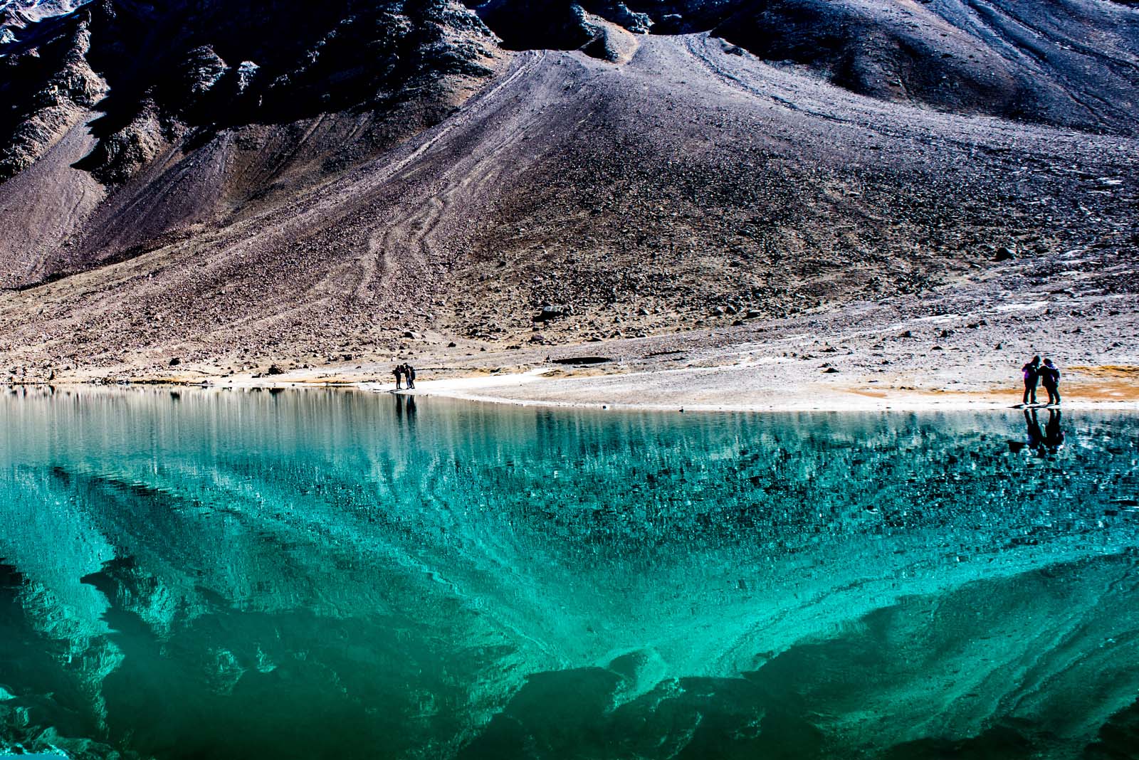
Arrive at Chandratal, the Moon Lake.
Photography Tips:
Capture the changing colors of the lake during different times of the day.
Photograph the starry night sky over Chandratal if they allow you to go. Nowadays, its probibited to go at night.
We start early this day (around 8am) after two days of relaxed travelling. Crossing Kunzum Pass (15,000 ft / 4,572 m) is a thrilling experience, where the barren landscape suddenly gives way to expansive vistas of snow-capped peaks and endless sky.
The whole drive is very interesting and we stop at multiple places to take pictures.
We reach Chandratal by afternoon, take some rest and then go to the lake in the evening. Its a photograpers dream to be here. It is very cold and windy here, so please keep yourself protected. There is no bad weather, only bad clothes.
Here, there is no choice but to stay in tents. These are luxury tents with attached washroom (you cannot take bath here though). The tent flutters all the night due to strong winds. Also because of the altitude, you don't get proper sleep, but its okay. We decend to lower altitide the next day and things will be fine.
Where does the Chandra river begins and ends?
The Chandra River originates from a glacier near the Chandra Taal lake in the Lahaul and Spiti district of Himachal Pradesh. It then flows southeast for about 88 km, eventually meeting the Bhaga River at Tandi. The combined river is then known as the Chenab (or Chandrabhaga), which flows through Jammu and Kashmir and into Pakistan, ultimately joining the Indus River.
🗓️ Day 9: Chandratal to Mandi via Atal Tunnel
Distance: ~200 km
Driving Time: ~8 hours
Altitude: Mandi (3,000 ft / 914 m)
Highlights:
After the really bad roads, cross the Atal Tunnel.
Descend to Mandi, a town nestled in the Beas River Valley.
Explore the local temples and markets.
Photography Tips:
Capture the descent from Kunzum Pass.
Photograph the temples and river landscapes in Mandi.
We go back to the lake in the morning before sunrise. After having breakfast, we leave for a long drive to Mandi on one of the worst roads in India.
The drive (~200 km / ~8 hours) is long but rewarding, with numerous opportunities to capture the changing scenery. The rugged terrain slowly gives way to dense forests, river valleys, and small villages. We reach Mandi by evening and just have enough patience to have dinner and go to bed.
🗓️ Day 10: Mandi to Chandigarh
Distance: ~200 km
Driving Time: ~4 hours
Altitude: Chandigarh (1,100 ft / 335 m)
Highlights:
Drive back to Chandigarh airport.
The final leg of the journey brings you back to Chandigarh (~200 km / ~4 hours). Our today's destination is the Chandigarh airport.
Any flight after 2pm works well.
My Chandratal Lake Spiti Valley Pictures
See my pictures of Chandratal Lake, Spiti Valley in better resolution here .
(for computer users)Tips for photographers
Must Read these links if you need Information on Travelling to Ladakh / Spiti
Milky Way Photography Spiti Valley
Best Places for Landscape Photography in India
Join My Spiti Photography Tour
Join My Ladakh Photography Tour
If you want a customized tour anywhere in India focused on Photography, I will be happy to organise it for you.
Thanksgiving
Thanks to all who believed in me and joined me for this tour.
All rights reserved. No copying without permission of the author Saurabh Chatterjee